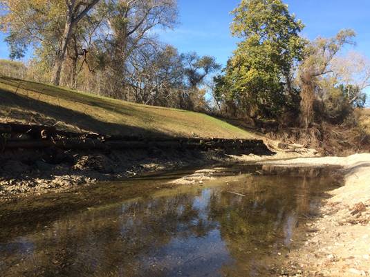
ITEM:

INFORMATIONAL ITEMS/STAFF REPORTS


25.

QUARTERLY CARMEL RIVER RIPARIAN CORRIDOR MANAGEMENT PROGRAM REPORT


Meeting Date:

January 23, 2019

Budgeted:

N/A


From:

Dave Stoldt,

Program/

N/A


General Manager

Line Item No.:


Prepared By:

Thomas Christensen and

Cost Estimate:

N/A


Larry Hampson


General Counsel Review:  N/A

Committee Recommendation:  N/A

CEQA Compliance:  This action does not constitute a project as defined by the California Environmental Quality Act Guidelines Section 15378.


IRRIGATION OF RIPARIAN VEGETATION: The supplemental watering of riparian restoration plantings was carried out for the dry season in 2018 at six Monterey Peninsula Water Management District (District) riparian habitat restoration sites.  The following irrigation systems were in use March through November: deDampierre, Trail and Saddle Club, Begonia, Valley Hills, Schulte, and Schulte Bridge.


            Water Use in Acre-Feet (AF)

            (preliminary values subject to revision)


            January - March 2018             0.82 AF

            April - June 2018                    3.41

            July – September 2018           4.79

            October – December 2018      2.89 AF


            Year-to-date                            11.91 AF


MONITORING OF RIPARIAN VEGETATION:   Starting in June 2018, staff recorded monthly observations of canopy vigor on target willow and cottonwood trees to provide an indication of plant water stress and corresponding soil moisture levels.  Four locations (Rancho Cañada, San Carlos, Valley Hills, and Schulte) are monitored monthly for canopy ratings based on a scale from one to ten. This scale evaluates characteristics such as yellowing leaves and percentages of defoliation (see scale on Exhibit 25-A).  A total of 12 willows and 12 cottonwoods at these locations provide a data set of established and planted sample trees that are representative of trees in the Carmel River riparian corridor. Combined with monthly readings from the District’s array of monitoring wells and pumping records for large-capacity Carmel Valley wells in the California American Water service area, the District’s monitoring provides insight into the status of soil moisture through the riparian corridor.


Monitoring results for the 2018 season show that riparian vegetation was below threshold moisture stress levels because of adequate soil moisture. The graph in Exhibit 25-A shows average canopy ratings for willows and cottonwoods in selected restoration sites in lower Carmel Valley.  The graph in Exhibit 25-B shows impacts to water table elevations.


The types of monitoring measurements made during June - October 2017 are as follows:


            Monitoring Measurement                                       


            Canopy ratings                                                (See Exhibit 25-A for trends.)          

            Groundwater levels (monitoring wells)          (See Exhibit 25-B for trends.)          

            Groundwater pumping (production wells)


OTHER TASKS PERFORMED SINCE THE OCTOBER 2018 QUARTERLY REPORT:


1.                  Rancho San Carlos Bank Stabilization Project: The Rancho San Carlos Bank Stabilization Project was completed on October 31, 2018.  In the winter of 2016-2017 this reach experienced significant erosion which created a potential threat to houses in the area and the loss of mature riparian forest. This project was designed to prevent additional bank erosion and incorporate new plantings to reestablish native streamside habitat. The project consisted of protecting the left bank with a 165 foot long log cribwall. The right bank was protected with riprap and anchored rootwads with additional gravel and cobble to support the bank.


2.                  Concrete Bridge Pier and Deck Removal: During the March 10, 1995 flood, the furthest downstream bridge on the Rancho Cañada Golf Course collapsed. A concrete center pier and the bridge deck fell into the river and remained there for 23 years. The District recognized an opportunity to remove the concrete as a mitigation offset for work being carried out at the Sleepy Hollow Steelhead Rearing Facility (SHSRF).


IMG_4987

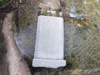
                        Concrete Bridge Pier before removal (Spring 2018)


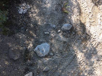
                        Concrete Bridge Pier removed from channel bottom (Fall 2018)


3.                  Los Padres Dam Long-Term Plan:  The Technical Review Committee (TRC) for sediment management held several meetings to review the results of sediment transport model development and scenario analysis.  Preliminary results indicate potential changes in the bottom of the Carmel River channel of -5 to +5 feet in the lower several miles of the river, depending on the supply of sediment from the upper watershed.  Alternatives range from no change to a resumption of the natural load.  While the model shows results for a 60-year analysis period, modeled river channel adjustments generally occur within the first 10 to 20 years after a change in supply.


Los Padres Dam Fish Passage Study:  The fish passage TRC met in November 2018 to consider several alternatives to improve upstream and downstream passage.  Several alternatives were eliminated due to complexity and uncertainty of benefits. 


It is expected that the two TRCs will need one or two additional meetings before a report of findings can be prepared.


4.                  Integrated Regional Water Management: Staff participated in several meetings to review regional goals and objectives and to expand the Regional Water Management Group.  Please see related information in this Board packet under Action items.


EXHIBITS

25-A    Average Willow and Cottonwood Canopy Rating

25-B    Depth to Groundwater


U:\staff\Boardpacket\2019\20190123\InfoItems\25\Item-25.docx