|
ITEM: |
INFORMATIONAL
ITEMS/STAFF REPORTS |
||||
|
|
|||||
|
23. |
CARMEL RIVER FISHERY REPORT FOR JANUARY 2017 |
||||
|
|
|||||
|
Meeting Date: |
February 22, 2017 |
Budgeted: |
N/A |
||
|
|
|||||
|
From: |
David J. Stoldt, |
Program/ |
N/A |
||
|
|
General Manager |
Line Item No.: |
|
||
|
|
|
|
|||
|
Prepared By: |
Beverly Chaney |
Cost Estimate: |
N/A |
||
|
|
|||||
|
General
Counsel Review: N/A |
|||||
|
Committee Recommendation: N/A |
|||||
|
CEQA Compliance: No CEQA Required |
|||||
AQUATIC HABITAT AND FLOW CONDITIONS: Due to the wettest
January since 1998, Carmel River flows were high throughout the month with two
peaks greater than 8,000 cubic feet-per-second (cfs) at the USGS Near Carmel
Gage (see graph).
Unusually high
turbidity levels, up to 1,200 Nephelometric Turbidity Unit (NTU), were
measured at the Sleepy Hollow Gage (USGS), caused by erosion at the recently
completed Carmel River Reroute & San Clemente Dam
Removal (CRRDR) restoration site and the 2016 Soberanes Fire. In addition
to the high suspended sediment load, vast quantities of sand were also
transported downstream in the high flows, filling pools and forming bars
between the old San Clemente Dam (SCD) site and the lower valley.
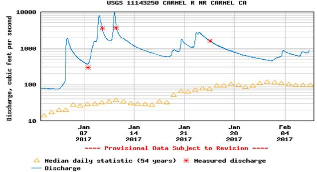
Mean daily streamflow at the Sleepy Hollow Weir ranged from 39 to 3,040
cfs (monthly mean 901 cfs) resulting in 55,370 acre-feet (AF) of runoff.
The Highway 1 gage was rewetted on December 9 and the January monthly flow
ranged from 38 to 4,110 cfs (monthly mean 897 cfs), resulting in 55,170 AF
of runoff.
January had 11.44 inches
of rainfall as recorded at Cal-Am’s San Clemente gauge (17.18 inches at Los
Padres Dam and even more in the highest peaks). The rainfall total for WY 2017
(which started on October 1, 2016) is 18.79 inches, or 170% of the long-term
year-to-date average of 11.08 inches.
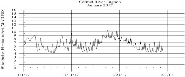
CARMEL RIVER
LAGOON: The lagoon began filling December 9th and
spilled naturally (without mechanical breeching) to the south on December 19th after
reaching ~14.2 feet water surface elevation (WSE) above mean-sea-level (NAVD
1988 datum). During January 2017, the WSE
ranged from approximately 4.0 - 10.3 feet above mean-sea-level (see graph
below).
Water-quality profiles
were conducted at five lagoon sites on January 18th. Conditions were generally
“excellent” with high dissolved oxygen (DO) levels (1.5 – 11.5 mg/l), and low
salinity (0.5-2.5 ppt) and water temperatures (50-52
degrees Fahrenheit). High, turbulent discharge
with moderately high turbidity levels (25 NTU) may have affected fish migration
through the lagoon.
DIDSON FISH COUNTER: The DIDSON (dual-frequency identification
sonar) acoustic camera was installed in the lower river on December 28, 2016
and is currently up and running. The camera made it through January’s high flow
peaks (up to 10,000 cfs) with no damage. By analyzing the computerized sonar
images from the camera, District staff will be able to estimate the number of
adult steelhead migrating up and down the river.
LOS PADRES DAM ADULT COUNTS: Cal-Am began their adult steelhead trap and
truck operations at LPD on December 19, 2016.
By the end of January 2017, three resident fish
(<16”, non-ocean run) had been trapped and transported upstream by Cal-Am
employees.
Additionally,
the LPD Smolt Emigration Facility began operation on
January 20, 2017.
SLEEPY HOLLOW STEELHEAD REARING
FACILITY: The Facility was decommissioned
for the winter season in early December after the release of all fish (see the
January 25 Board Meeting for details).
During the January storm events, the Facility sustained only minor
damage, primarily to the lower end of the rearing channel.
U:\staff\Boardpacket\2017\20170222\InfoItems\23\Item-23.docx