EXHIBIT 6-B
Project 9 Implementation Plan
Project 9 -
Feasibility of Scenic Road Protection and Preservation with Proposed Carmel
River Lagoon Ecosystem Protective Barrier
Background
The purpose
of this project is to carry out a planning and feasibility study for protection
and preservation of Scenic Road as it pertains to the installation of the
proposed Carmel River Lagoon Ecosystem Protective Barrier (EPB), near the
California State Parks Carmel River Lagoon and Wetlands Natural Reserve in
Monterey County (Figure A).
The Carmel
River Lagoon (Lagoon) forms a seasonally brackish lagoon environment above sea
level at the mouth of the Carmel River, and tidal forces frequently build the
barrier beach up across the mouth to a level that is higher than some of the
surrounding homes and infrastructure.
When the Lagoon rises from wave overwash or Carmel River inflow, the
beach must be breached mechanically in order to lower the water level. These actions result in a loss of aquatic
habitat and undesirable consequences to fish and wildlife. Installation of an EPB along the northern
portion of the lagoon could allow the Lagoon to rise to a higher level on more
frequent occasions while reducing the potential for flooding of low-lying
structures. Research of the barrier
beach by the Monterey Peninsula Water Management District indicates that
without mechanical breaches to control the location of the lagoon outlet, the
river tends to meander across the beach in response to the changing river
flows, tides and swell environment. When
the river flows out to the north, the combination of river flow and
ocean waves can erode the sand dune material supporting Scenic Road. Scenic Road provides local access for
homeowners and is an important link in maintaining public access to coastal
resources.
·
An
EPB could reduce the potential for flooding due to high Carmel River flows, and
would allow the Lagoon to double in volume and could result in an overall
increase in water quantity and quality throughout the dry season.
·
The rest of the EPB analysis is being completed
with funds from California American Water customers in the Monterey Peninsula
region and with in-kind services from local agencies and non-profit groups,
with funds administered through the Wildlife Conservation Board (WCB). The WCB grant funds and local
in-kind services do not include an
investigation of methods to protect Scenic Road from erosion and tie in to the
barrier project proposed for the north side of the lagoon.
·
Funds from the Department of Water Resources
provided through the Prop. 84 Integrated Regional Water Management grant
program will allow the EPB feasibility analysis to be expanded to investigate
the feasibility of tying the EPB into a project that will preserve the bluff
underlying Scenic Road and prevent further damage from high ocean swells and/or
river flows adjacent to Scenic Road.
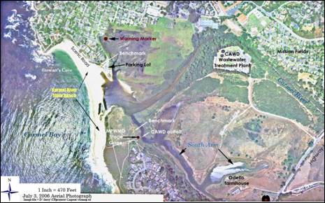
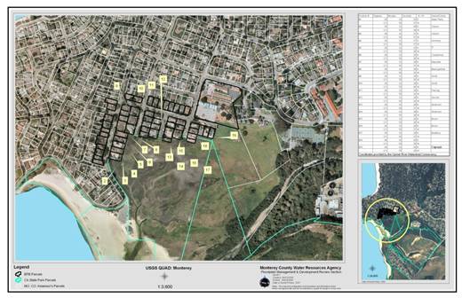
Figure A.
Location Maps. Above: general location; below:
parcels affected by flooding.
Work Plan
Task 1:
Data Review
Review
existing literature including studies of the topography, bathymetry,
geotechnical investigations, and historical changes of the bluff and beach
along Scenic Road between the Carmel River State Beach parking lot and the
intersection of Ocean View Avenue with Scenic Road (along the area known as
Stewart’s Cove). If historical data are
available, summarize data on the changes in height and width of the beach area
along Scenic Road within the Stewart’s Cove area.
Task 1 Deliverables: Summary of Data Review
Task 2:
Survey Data Augmentation (if
necessary)
If
necessary, survey data of the Scenic Road profile for the section of Scenic
Road described in Task 1 shall be obtained.
Data density should be sufficient to show the width of the road and
changes in grade along the edge closest to the ocean. If current survey data of the adjacent beach
has not already been obtained (i.e., from summer 2011 or later), obtain
cross-sections along the road at 100-foot intervals. Cross-sections are to show the road elevation
within the Monterey County right-of-way (i.e., right edge, center and left
edge) and are to extend to the mean low tide elevation.
Task 2 Deliverables: Survey data (NAVD 1988)
point files, topographic base map, plots of cross-sections and profile.
Task 3:
Geotechnical Analyses (additional data will be acquired, if necessary)
If
insufficient geotechnical information is available along Scenic Road between
the limits described in Task 1, obtain geotechnical information that will
provide information on the subsurface profile under and immediately adjacent to
the road. This could include borings
and/or geophysical survey work using ground-penetrating radar and/or seismic
refraction analysis. The method to be
used will be determined after a review of existing geotechnical, topographic,
and bathymetric information is completed.
Task 3 Deliverables: Results and summary report
of geotechnical investigation including data acquired during the investigation
(such as boring logs, laboratory analysis, or other data).
Task 4:
Planning-Level Schematic and Planning-Level Cost Estimate
Determine
what options may be available to protect Scenic Road from erosion during large
ocean swell events or during periods when the Carmel River flows out to the
north along Scenic Road.
Task 4 Deliverables: Technical Memorandum
describing options for protecting Scenic Road.
The TM is to include a planning level schematic showing options for
protecting Scenic Road and an initial estimate of the cost for reach option.
Task 5:
Description of Scenic Road Protection and Preservation with the Proposed
EPB
Using
information from Tasks 1-4, and information from the proposed Carmel River
Lagoon Ecosystem Protective Barrier (EPB) study, recommend where improvements
along Scenic Road should start and finish.
If protection along Scenic Road is proposed to extend into the parking
lot on State Parks land along the Carmel River State Beach, describe how the
protection will be tied into the barrier proposed along the north side of the
lagoon.
Task 5 Deliverables: Report or Technical
Memorandum describing recommended Scenic Road improvements.
Project
Schedule
|
|
Task
Name |
Duration |
Start |
Finish |
Milestone |
|
P9 |
Project 9 -
Feasibility of Scenic Road Protection and Preservation with Proposed Carmel
River Lagoon Ecosystem Protective Barrier |
487 |
12/1/2011 |
4/1/2013 |
|
|
Task 1 |
Data Review |
4/1/2013 |
|||
|
Task 2 |
Survey Data Augmentation |
7/1/2012 |
|||
|
Task 3 |
Geotechnical Analyses |
2/1/2013 |
|||
|
Task 4 |
Planning-Level
Schematic and Planning-Level Cost Estimate |
4/1/2013 |
|||
|
Task 5 |
Description of Scenic Road Protection and
Preservation with the Proposed EPB |
4/1/2013 |
Project
Budget
|
Budget
Description |
Funding
Match |
Grant
Funding |
Other
State Funds Used |
Estimated
DAC Costs from DWR Grant |
Total |
%
Match |
|
Project
9 - Carmel River Lagoon Ecosystem Protective Barrier Planning and Feasibility |
|
$54,200 |
|
|
$54,200 |
0% |
|
Task
1: Data Review |
$5,000 |
|
|
|
$5,000 |
|
|
Task
2: Survey Data Augmentation (if
required) |
$10,000 |
|
|
|
$10,000 |
|
|
Task
3: Geotechnical Analyses |
$20,000 |
|
|
|
$20,000 |
|
|
Task
4: Planning-Level Schematic and
Planning-Level Cost Estimate |
$14,200 |
|
|
|
$14,200 |
|
|
Task
5: Description of Scenic Road
Protection and Preservation with Proposed EPB |
$5,000 |
|
|
|
$5,000 |
|
U:\staff\word\boardpacket\2011\20111212\ConsentCal\06\item6_exh6b.docx