Project
3 Implementation Plan
Project 3 Assessment of Steelhead Passage Barriers in Portions of Four Tributaries to the Carmel
River Main Stem
Background
The decline of steelhead in
the Carmel River Basin between the 1960s and 1990s prompted its listing as a
threatened species under the protection of the federal Endangered Species Act
(ESA). In normal and above water years,
adult steelhead can spawn in a total of 60.5 miles of stream, including 24.5 miles
of the Carmel River main stem, 30 miles of primary tributaries, and 6 miles of
secondary tributaries. A thorough,
detailed survey needs to be completed of all potential barriers to steelhead
migration. This scope of work includes
an analysis of barriers in tributary streams that are judged to be the most
important in terms of potential steelhead habitat (Figure 1). The District selected four major tributaries
for this assessment: Potrero Creek,
Cachagua Creek, Pine Creek and San Clemente Creek, and added one potential
barrier known as Flavin’s Ford.
Forty-four reconnaissance sites and a maximum of 40 sites with detailed
measurements are proposed for this barrier assessment. Of the total
reconnaissance sites, 31 are on private property and 13 are on public property.
The priorities for this
assessment will be to 1) provide a description of existing passage barriers; 2)
document and confirm the amount of stream channel accessible to steelhead in
selected tributaries under natural conditions; 3) locate, delineate, survey and
rank manmade barriers; 4) develop a prioritized list of actions/modifications
at each barrier that will ultimately maximize production of juvenile steelhead
from each tributary; and 5) recommend modifications to eliminate temporal
migration delays and any partial blockages in selected tributaries.
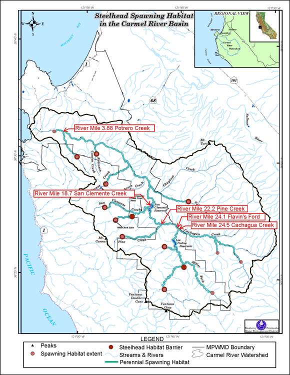
Figure 1. Carmel River
Basin showing principle tributaries and extent of stream habitat accessible to
adult steelhead. (MPWMD 2005)
WORK
PLAN
Task
1: Obtain Access & Permission for
Work
Subtask 1.1 Develop parcel list and contact information of property owners along each
tributary and the main stem between San Clemente Reservoir and Los Padres Dam,
and contact each landowner for permission to conduct the assessments.
Subtask 1.2 Hold a workshop for property owners.
MPWMD will provide a parcel list and contact information of private
property owners along each tributary and the main stem between San Clemente
Reservoir and Los Padres Dam. The
Consultant is to contact each landowner and invite them to a workshop to discuss
the barrier assessments. The Consultant
will arrange for a meeting place, date, and time. MPWMD will send representatives to the
workshop to describe the project and to request that owners grant access to
MPWMD for barrier assessments.
Subtask 1.3 Negotiate agreements for access to cover the study period. If necessary, after conducting a workshop,
the Consultant will follow up with individual property owners to obtain access
permission to conduct assessments.
Task 1 Deliverables: List of property owners contacted; copies of access agreements
obtained.
Task
2: Conduct Reconnaissance Surveys and
Update Existing Information
Barrier assessment will be initiated by conducting a
reconnaissance survey of each study stream to verify previously described
barriers and identify new potential barriers.
Information collected will
include: barrier type (road crossing, steep riffle, seasonal dam, bedrock
chute, waterfall, log jam, etc.), location by Latitude/Longitude coordinates,
overall gradient upstream and downstream of barrier, initial determination of
migration constraints such as water velocity, jump height or both, and
representative photos above and below the potential barrier. To supplement previous work on the selected
tributaries, the uppermost natural barrier to fish migration will be located
and described.
Subtask
2.1 Potrero
Creek: 3 miles, one day, two surveyors
Subtask
2.2 San
Clemente Creek Basin: 8 miles, 4 days, two surveyors
Subtask
2.3 Pine
Creek: 5.5 miles, 3 days, two surveyors
Subtask
2.4 Flavin's
Ford: one site, 0.25 days, two surveyors
Subtask
2.5 Cachagua
Creek Basin: 16 miles, six days, two surveyors
Subtask
2.6 Update
Barrier Maps and prepare Preliminary Report
Subtask
2.7 Select
Sites for Detailed Assessments
Task 2 Deliverables: Geographic location data and characterization
of potential barriers.
Task
3: Detailed Barrier Assessments
This task will employ a two-staged approach based on
techniques developed by the United States Forest Service (2005 and 2008) and
the California Department of Fish and Game (CDFG) (2010). This approach will incorporate a screening
process, using site specific geomorphic and hydrologic data of barriers in each
stream, which will then be compared to a set of criteria to rank the
barriers. The protocol includes
measurements of channel profile, x-sections, substrate composition, the size
and shape of culverts or channel obstructions, flow characteristics, sketches,
and photo documentation of potential barriers.
The goal of this two-staged approach is to inventory, evaluate and rank
the sites according to the general framework recommended by the CDFG’s
California Salmonid Stream Habitat Restoration Manual. The results of the evaluation will provide
guidance on the priority for treating sites with the goal of eventually
providing unimpeded fish access to the uppermost natural total barrier in each
tributary.
Subtask 3.1 Potrero Creek
Surveys: (7 road crossings, one steep riffle; 4 hours each; 2 two surveyors per
site)
Subtask 3.2 San Clemente Creek
Survey: (4 road crossings, one summer dam, two permanent dams, one delta; 4
hours each for roads and summer dam, 8 hours each for permanent dams and delta;
2 two surveyors per site)
Subtask 3.3 Pine Creek Survey:
(bedrock chute at confluence; one day; two surveyors)
Subtask 3.4 Flavin's Ford
Survey: (one concrete road crossing; one day; two surveyors)
Subtask 3.5 Cachagua Creek,
Lower Reach Survey: (4 County Road Bridges, 8 private road crossing; 2 hours
each for County road bridges and 4 hours each for private road crossings)
Subtask 3.6 Cachagua Creek
Basin, Upper Reach, Finch, James and Martin Creeks Upper Reach Survey: (4
County road crossings, 8 private road crossing; 4 hours per crossing)
Subtask 3.7 Data Entry: 37
sites x 1 hour per site
Subtask
3.8 Data
Analysis: 37 sites x 2 hours per site
Subtask
3.9 Summary
Report and Site Ranking
Task 3 Deliverables: Geomorphic and hydrologic data of barriers in
each stream; inventory, evaluation, and rank for each site evaluated.
Task
4: Collect and provide streamflow data
for WY 2009, 2010, 2011
Task 4 Deliverables: Summary of annual
streamflow data for each tributary (mean daily flow).
Project
Schedule
|
|
Task Name |
Duration |
Start |
Finish |
Milestone |
|
P3 |
Project
3 - Assessment of Steelhead Passage Barriers:
Four Tributaries to Carmel
River Main Stem |
1492 |
10/1/2008 |
11/1/2012 |
|
|
Task 1 |
Obtain Access & Permission for Work |
6/1/2012 |
|||
|
Task 2 |
Conduct Reconnaissance Surveys and Update
Existing Information |
7/1/2012 |
|||
|
Task 3 |
Detailed Barrier Assessments |
11/1/2012 |
|||
|
Task 4 |
Collect and Provide Streamflow Data for WY
2009, 2010, 2011 |
ongoing |
Project Budget
|
Budget Description |
Funding Match |
Grant Funding |
Other State Funds Used |
Estimated DAC Costs from DWR Grant |
Total |
% Match |
||
|
Project
3 - Assessment of Steelhead Passage Barriers in the Carmel River Watershed |
$59,450 (MPWMD in-kind services for tributary
streamflow gauging) |
$65,000 |
$0 |
$0 |
$124,450 |
48% |
||
|
Task
1: Obtain Access & Permission for
Work |
$0 |
$8,000 |
$0 |
$0 |
$8,000 |
|
||
|
1.1 Develop parcel list and
contact information |
|
$2,000 |
|
|
|
|
||
|
1.2 Hold meeting/workshop for
property owners |
|
$2,000 |
|
|
|
|
||
|
1.3 Negotiate agreements for
access |
|
$4,000 |
|
|
|
|
||
|
Task
2: Conduct Reconnaissance Surveys and
Update Existing Information |
$0 |
$22,000 |
$0 |
$0 |
$22,000 |
|
||
|
2.1 Portrero
Creek |
|
$1,200 |
|
|
|
|
||
|
2.2 San Clemente Creek Basin |
|
$4,800 |
|
|
|
|
||
|
2.3 Pine Creek |
|
$3,500 |
|
|
|
|
||
|
2.4 Flavin's Ford |
|
$300 |
|
|
|
|
||
|
2.5 Cachagua Creek Basin |
|
$7,200 |
|
|
|
|
||
|
2.6 Update Barrier Maps &
Preliminary Report |
|
$4,000 |
|
|
|
|
||
|
2.7 Select Sites for Detailed
Assessments |
|
$1,000 |
|
|
|
|
||
|
Task
3: Detailed Barrier Assessments |
$0 |
$35,000 |
$0 |
$0 |
$35,000 |
|
||
|
3.1 Portrero
Creek Surveys |
|
$3,600 |
|
|
$3,600 |
|
||
|
3.2 San Clemente Creek Survey |
|
$6,000 |
|
|
$6,000 |
|
||
|
3.3 Pine Creek Survey |
|
$1,200 |
|
|
$1,200 |
|
||
|
3.4 Flavin's Ford Survey |
|
$1,200 |
|
|
$1,200 |
|
||
|
3.5 Cachagua Creek, Lower Reach
Survey |
|
$6,000 |
|
|
$6,000 |
|
||
|
3.6 Cachagua Creek Basin, Upper
Reach, Finch, James and Martin Creeks Upper Reach Survey |
|
$6,000 |
|
|
$6,000 |
|
||
|
3.7 Data Entry |
|
$1,000 |
|
|
$1,000 |
|
||
|
3.8 Data Analysis |
|
$6,000 |
|
|
$6,000 |
|
||
|
3.9 Summary Report & Site
Ranking |
|
$4,000 |
|
|
$4,000 |
|
||
|
Task
4: Collect and Provide Streamflow Data
(WY 2009, 2010, 2011 |
$59,450 |
$0 |
$0 |
$0 |
$59,450 |
48% |
||
U:\staff\word\boardpacket\2011\20111212\ConsentCal\06\item6_exh6a.docx