EXHIBIT 5-A
Amended Work Plan to Update
the
Integrated Regional
Water Management Plan
|
California American Water |
Monterey Bay Citizen Watershed Monitoring Network |
|
California Coastal Commission |
Monterey County Service Area 50 |
|
California Coastal Conservancy |
Monterey Peninsula Regional Park District |
|
California Department of Fish and Game |
NOAA Fisheries |
|
California State University Monterey Bay |
Pebble Beach Community Service District |
|
California State Water Resources Control Board |
Pebble Beach Company |
|
Carmel Area Wastewater District |
Planning and Conservation League |
|
Carmel River Steelhead Association |
Regional Water Quality Control Board |
|
Carmel River Watershed Conservancy |
Resources Conservation District of Monterey County |
|
Carmel Unified School District |
Santa Lucia Preserve |
|
Carmel Valley Association |
Seaside Basin Watermaster |
|
City of Carmel-by-the-Sea |
State Department of Parks & Recreation |
|
City of Del Rey Oaks |
Surfrider Foundation |
|
City of Pacific Grove |
The Nature Conservancy |
|
City of Sand City |
The Watershed Institute at CSUMB |
|
City of Seaside |
U.S. Army Corps of Engineers |
|
Fort Ord Environmental Justice Network |
U.S. Fish and Wildlife Serve |
|
Marina Coast Water District |
Ventana Wilderness Society |
|
Monterey Bay National Marine Sanctuary |
|
|
Regional Water
Management Group |
Work Plan Summary
This a summary of the Amended Work Plan to Update the Monterey Peninsula, Carmel Bay, and South
Monterey Bay Integrated Regional Water Management Plan, dated July 2011. The full Work Plan is on the District web
site at:
http://www.mpwmd.dst.ca.us/Mbay_IRWM/Mbay_IRWM.htm
The Work Plan supersedes the Work Plan submitted to the Department of Water Resources (DWR) on September 28, 2010 as part of a Planning Grant application. The amended work plan responds to a request by DWR for additional information and clarification about the Work Plan to update the Monterey Peninsula, Carmel Bay, and South Monterey Bay Integrated Regional Water Management (IRWM) Plan. The Work Plan has two related sets of tasks. Tasks 1 to 16 are associated with updating the adopted IRWM Plan and includes the addition of a new chapter on Global Climate Change. Projects 1 through 9 are individual planning projects that will be incorporated into the IRWM Plan update either directly or by reference (e.g., as a local plan). The scope of work for Tasks 1 through 16 was determined by reviewing the IRWM Plan adopted in 2007 and comparing that plan with changed conditions in the planning region and with the Prop. 84 IRWM Guidelines (Guidelines) issued by DWR in August 2010. As a result of that review, Tasks 1 through 16 will require several significant changes to the IRWM Plan and will also bring the IRWM Plan into conformance with standards described in the Guidelines.
Task 17 is Grant Administration, which consists of grant oversight and administration by the Monterey Peninsula Water Management District (MPWMD), including preparation and administration of sub-grantee agreements, quarterly reports, and a final report.
Projects 1 through 9 address a variety of planning efforts, some of which build on previous planning projects funded by DWR and also help to address regional priorities described within the existing IRWM Plan. Results and recommendations from each separate project will support efforts to achieve Proposition 84 IRWM Plan standards. It is expected that information from these projects will be used to develop additional projects to be included in the IRWM Plan for implementation.
The “Task List Summary” beginning on page 18 of the full Work Plan contains brief information describing each task, how the task will address changes from the adopted plan to the Prop. 84 plan and standards described in the Guidelines, and a list of deliverables. The Chapter format for the updated IRWM Plan will be changed from its current format in order to follow Prop. 84 Plan Standards, i.e., chapter headings will parallel the General Program Requirements for the IRWM Grant Program.
During meetings in 2009 and 2010 to discuss the contents of a grant application to the IRWM program, stakeholders were informed of the new Prop. 84 Guidelines and were asked to identify planning tasks that could improve elements or projects in the adopted IRWM Plan and address issues that had not been included in the adopted IRWM Plan. This Work Plan covers nearly every geographic area within the region and improves the region’s ability to meet the five regional priorities described in the 2007 plan.
Regional Priorities:
· meet current replacement supply and future demand targets for water supply and support the Seaside Groundwater Basin Watermaster to implement the physical solution in the Basin
·
reduce the potential for flooding in Carmel
Valley and at the Carmel River Lagoon
·
mitigate effects of storm water runoff
throughout the planning Region
·
address storm water discharges into Areas of
Special Biological Significance
·
promote the steelhead run
Tasks 1-17 – Tasks 1-15 describe work to update each Chapter of the adopted IRWM Plan and reorganize the plan to be consistent with Prop. 84 IRWM Plan standards. Task 16 will create a new chapter in the IRWM Plan on the potential local effects of global climate change. Task 17 is grant administration.
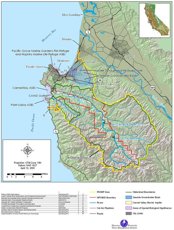
· Project 1 – An update to the Canyon Del Rey watershed portion of the Monterey County Master Drainage Plan. This watershed area was initially assessed in 1977 and several improvements were recommended. Work in this task includes an update to the description of infrastructure, analysis of current problem areas, and will help fill in a gap in the region’s planning efforts by defining the needs for future improvements. Flooding and bank erosion along the Highway 68/Highway 218 corridor and sedimentation of the two lakes at the terminus of the watershed (Roberts Lake and Laguna Grande) are the primary issues to focus on in an update. The potential to combine resource strategies and project alternatives to meet multiple IRWM plan objectives will be evaluated. Resource strategies that could be combined with flood and erosion control planning include water quality improvement, groundwater recharge, water conservation, and habitat restoration. Recreation trails have been constructed in some areas along the stream corridor. The potential to develop this further will be examined.
· Project 2 – Development of a salt and nutrient management plan for the Seaside Groundwater Basin. The SGB currently provides about 25% of the region’s water supply and is slated for much greater use in the future with proposals for injecting or percolating freshwater, desalinated water, and recycled water and recovering the water for use in satisfying municipal demand. Entities in the region are also interested in using the basin as a place of storage for stormwater. Currently, this basin is threatened by seawater intrusion and was adjudicated in 2007. This project will enable recycled water projects to meet the requirements of the California State Water Resources Control Board Recycled Water Policy, which was adopted in 2009, and requires a plan to recognize salt and nutrient loading and to implement a program to reduce the effects on groundwater quality.
· Project 3 – Assessment of steelhead passage barriers in portions of four tributaries to the Carmel River main stem. Carmel River steelhead are listed as a threatened species. After rebounding from a record low of one adult fish counted at the San Clemente Dam fish ladder in 1991 to nearly 900 adults in 1999, the adult run of steelhead has trended downward and is currently at a level of between just over 100 to 400 adults annually. In the winter 2010-11 migration season, a total of 452 adults were counted at the ladder. The downward trend has occurred during a relatively wet period in which 13 of the last 16 years have seen above-average rainfall in the watershed and during a period that the streamside riparian corridor has increased more than 46% (between 1986 and 2001). Restoration of steelhead habitat in the Carmel River watershed was designated as one of five regional priorities in the IRWM Plan.
Tributaries to the main stem provide approximately 25% of the annual flow in the Carmel River and comprise about 50% of the available rearing habitat in the watershed[1]. The basin has not had a detailed barrier assessment, but there are many known potential barriers to upstream adult migration. Each of the streams targeted for a barrier assessment is known to have had adults spawn in the stream (young of year and juveniles have been rescued out of these tributaries before they run dry). The assessment work includes private property owner outreach, field assessment along about 20 miles of streams, prioritization of barriers to be removed, and recommendations about methods to remove or modify the barriers. A desired outcome is to prepare analyses that can be used to develop final design plans for barrier removal.
· Project 4 – Geographic Information Systems and Internet Mapping Site Development. A major obstacle to timely integration of projects and evaluation of their merits is a lack of a common, accessible, and user-friendly database and system to enter and analyze project information. This project will take the first steps in moving the planning region toward an interactive web process for the region’s stakeholders to develop, analyze, communicate, and evaluate project proposals and their results. Work associated with this task will result in the development of IRWM Document Management Software (IRWM-DMS) to be used in updating the IRWM Plan and in providing stakeholders with web-based tools to improve data and water resources management in the region.
· Project 5 – Inter-Regional Coordination between the Greater Monterey County IRWM Plan and the Monterey Peninsula, Carmel Bay, and South Monterey Bay IRWM Plan. The two planning regions have a common interest in water resource management of the Seaside Groundwater Basin and the northern portion of the Salinas Valley Groundwater Basin. Several agencies within both planning regions share responsibilities for this area. Coordination between the two regions is a key aspect for redevelopment of the Ord Community (the former Fort Ord) and for future water supply projects to meet the needs of the Monterey Peninsula.
· Project 6 – San Jose Creek Watershed Plan. A complete, steelhead-centric, physical watershed assessment is proposed that will lead to a prioritized list of watershed management actions. The assessment will integrate information from sediment source analysis, hydrologic data, barrier evaluations, and lagoon monitoring.
· Project 7 – City of Monterey and Pacific Grove ASBS refined 2006 feasibility study of alternatives Management Plan. In 2006, the City of Monterey carried out an extensive analysis of alternatives for stormwater discharges to ASBS with funding from a DWR Planning Grant. Project 7 will build the results of that study and complete further analysis of two of the top-ranked alternatives with a goal of completing a CEQA environmental analysis for a project.
· Project 8 – Hydrologic Modeling for the Carmel Valley Alluvial Aquifer. This task will begin the development of a model that will provide the ability to simulate and better manage the interaction between streamflow and groundwater movement in the portions of the Carmel River that flow over and through the Alluvial Aquifer. The Carmel Valley Alluvial Aquifer and the Carmel River have been modeled with various techniques in the past. However, many of these models are not current, and should be evaluated with respect to the ability of the models to answer questions necessary to best manage the coupled resource of the river flow and groundwater storage. Developing a new model will provide the ability to simulate and better manage the interaction between streamflow and groundwater movement in the portions of the Carmel River that flow over and through the Alluvial Aquifer. The lower 15.5 miles of the aquifer underlying and closely paralleling the surface water course of the Carmel River is water flowing in a subterranean stream and subject to the jurisdiction of the SWRCB (WRO 95-10).
·
Project
9 – Carmel River Lagoon Ecosystem Protective Barrier Planning and
Feasibility
The Carmel River Lagoon (Lagoon), which forms a seasonally brackish lagoon environment above sea level at the mouth of the Carmel River, is subject to frequent emergency actions along the barrier beach across the mouth of the lagoon in most winters in order to reduce the potential for flooding of nearby low-lying structures. These actions result in a loss of aquatic habitat and undesirable consequences to fish and wildlife, including impacts to the federally threatened species steelhead trout (Oncorhynchus mykiss) and California red-legged frogs (Rana daytonii) (CRLF). In addition, large swell events along the coast and outflows from the lagoon that flow north through the barrier beach periodically cause coastal erosion of the bluff supporting Scenic Road, which travels along the northern portion of Carmel Bay, and damage California Department of State Parks facilities at the Carmel River State Beach.
State Parks facilities that have been damaged include a parking lot and bathroom facilities. Scenic Road contains utility infrastructure, provides access for local property owners, and is a highly popular recreational route along the coast for walkers, cyclists, and vehicles driving between the City of Carmel to the north and Highway 1 to the south. Monterey County Public Works has taken emergency actions on several occasions since the early 1990s to prevent portions of Scenic Road from falling into the ocean. Public Works has characterized the slope supporting the road as fragile and subject to future erosion.
The purpose of this project is to carry out a planning and feasibility study for the proposed Carmel River Lagoon Ecosystem Protective Barrier (EPB or Barrier), located near the California State Parks Carmel River Wetlands Preserve in Monterey County. The primary goal is to conduct a feasibility study to determine if a floodwall could improve rearing habitat for the steelhead trout and CRLF. This project will investigate the feasibility of reducing or eliminating mechanical breaching of the barrier beach and evaluate if the use of a barrier will reduce the chance of flooding along the north edge of the Lagoon.
Because the beach is also mechanically managed to avoid damage to Scenic Road and State Parks facilities, additional funds from the Department of Water Resources provided through the Prop. 84 Integrated Regional Water Management grant program will allow the EPB analysis to be expanded to investigate the feasibility of a project to protect and preserve Scenic Road and potentially connect to the EPB to provide a comprehensive solution to the problems in this area.
U:\staff\word\boardpacket\2011\20110919\ConsentCal\05\item5_exh5a.docx