EXHIBIT 4-A
The Monterey Peninsula Water Management District
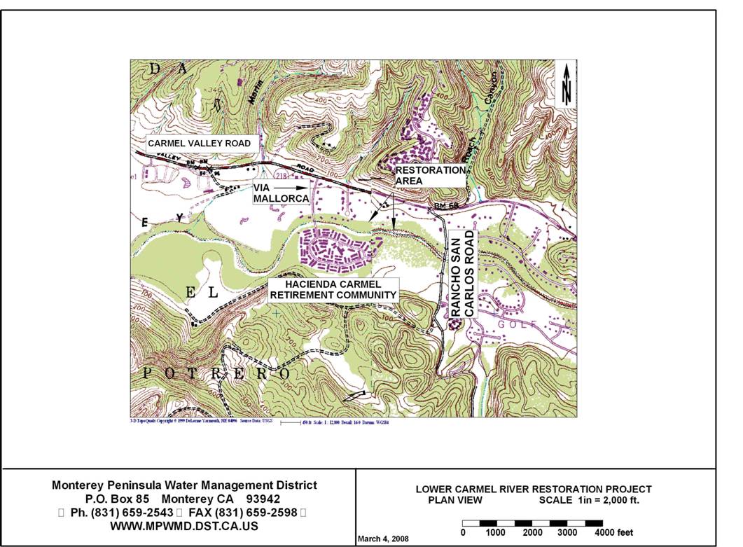
(MPWMD) is interested in developing a Lower Carmel River Restoration Project in
an 800-foot reach of the channel between Via Mallorca Road and Rancho San
Carlos Road (see plan view, next page).
Work would commence approximately 600 feet upstream of the Via Mallorca
Road Bridge at station 17,700 (measured from the ocean) and end approximately
800 feet upstream at approximately station 18,500. Basic survey data consisting of cross-sections
was obtained in the fall of 2007 and would be augmented with additional
topographic data. Field work would
include a minimum of one on-site meeting between the Consultant and MPWMD staff
to discuss potential streambank and floodplain restoration techniques that
would be appropriate for the site.
A preliminary design would be developed for use in
making a preliminary cost estimate, obtaining access permissions from affected
property owners and beginning the environmental review and permitting process.
Approach
The development of a preliminary design for the
Lower Carmel River Restoration Project involves field assessment and design
efforts. All designs will be completed
using state plane coordinates (NAD 83 for horizontal and NAVD 1988 for
vertical) to coincide with 2007 surveys.
The following tasks are anticipated:
Task 1 -
Field Assessment
The Consultant will meet at the site with MPWMD
staff to assess the existing condition of streambanks within the project and
determine the most appropriate method (s) to accomplish the following goals:
·
meet
requirements of Regional General Permit 24460S issued to MPWMD by the U.S.
Corps of Engineers for maintenance and restoration of the Carmel River
·
meet
expectations of adjacent property owners concerning protection of property
·
enhance fishery
and riparian habitat
Techniques to be considered may include (but not be
limited to) installation of rock vanes, construction of an inset floodplain,
streambank grading, selective use of rock slope protection, installation of
geotextiles, and revegetation with native riparian plants.
Task 2 -
Prepare a base map at a scale of 1 inch = 100 feet of the project area that
includes property lines, assessor’s parcel numbers, property owner names,
outstanding physical features, and major street names.
Task 3 -
On the base map, draw the proposed channel alignment and include the following:
project limits, cut and fill areas, low-flow (2,500 cfs) channel alignment,
fish migration channel, pools, areas of structural protection, and restoration
planting areas.
Task 4 -
Prepare a minimum of three typical design cross-sections showing existing and
proposed elevations, typical design slopes, dimensions, and structural
protection. Cross-sections should be at
a scale of 1 inch = 40 feet or 1 inch = 20 feet. Structural protection may include continuous
rock rip-rap in areas within 25 feet of structures, rock and log deflectors, rock
vanes, or other protection suitable for resisting erosion and providing
fisheries habitat enhancement.
Task 5 -
Prepare a preliminary quantity take-off.
Information will be presented in spreadsheet format.
Task 6 –
Prepare a Preliminary Design Engineers Report that will contain a brief
description of the site, its history, hydrology, the nature and extent of the
design, list of property owners by parcel number and address, list of parcels
that would have actual construction work on them, typical cross sections and
design details.
Information to be provided by MPWMD:
_ Access permission for field visit
_ Historical aerial photographs and survey data
_ Orthographic photo of the project site
_ GIS layer with property lines
_ Typical design cross sections for the MPWMD Carmel River Projects
_ List of property owners and assessor’s parcel numbers
Project Deliverables:
All design products will be delivered in both
digital file format (Excel .xls and/or Autocad .dwg format) and paper
copies. Given the reach size and
previous drawing layouts, all drawings will be prepared on E-size sheets. The digital files shall be provided on CD-ROM
or in an alternate format acceptable to the client. A conceptual design report
will be provided that describes the project area, lists property ownership and
identifies exactly which properties would have actual construction work
undertaken on them.
Two sets of bond plots and one set of reproducible
mylar plots will be provided.
Schedule:
All work is to be completed by June 30, 2008. It is anticipated that a field visit to
initiate the contract, exchange data, and assess the site would occur soon
after issuance of a contract notice to proceed in early April 2008. Draft designs would be provided by May 30 and
final products would be submitted by June 30, presuming that the MPWMD review
period takes no more than two weeks.
Estimated Budget:
Professional Services
Contract Kick-off meeting and travel = $
1000.00
2 field days for survey work @ 1,250/day = $
2500.00
2 office days @ $800/day for map preparation = $
1600.00
2 office days @ $1,000/day for Design Engineer = $ 2000.00
2 office days @ $1,200/day for Principal Designer = $ 2400.00
Total
Services: = $
9500.00
Expenses
Mileage: One
round trip to project site and local miles
estimated
at 800 miles @ $0.50/mi = $
400.00
Plotting Charges:
= $
100.00
Total Expenses: = $ 500.00
Total
Project Budget: = $10,000.00
The project will be undertaken on a
time-and-materials basis, for a not-to-exceed contract price. If field or office work takes less time than
budgeted, then only that amount is charged to the project.
U:\staff\word\boardpacket\2008\2008boardpackets\20080317\ConsentCal\04\item4_exh4a.doc